📍 Basic Information
-
Located in northeast West Bengal, within Jalpaiguri Division, bordering Jalpaiguri & Alipurduar (north), Assam to the east, and Bangladesh on two sides.
-
Area: approximately 3,387 km², or about 3.8% of West Bengal’s total area.
-
Terrain: flat with a slight south-eastern slope, mostly alluvial sandy loam soils; higher areas in Sitalkuchi, lower lands at Dinhata.
-
Former princely state of the Koch dynasty, merged into India in 1949–50.
🧭 Tourist Attractions
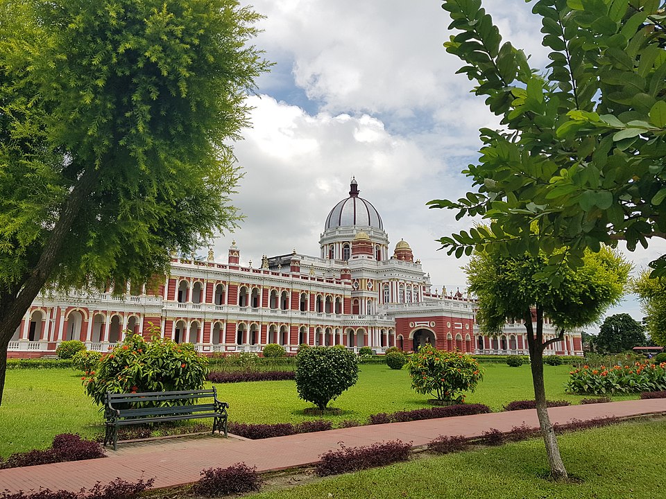
Cooch Behar Palace (Rajbari)
-
Built in 1887 by Maharaja Nripendra Narayan, designed in Italian Renaissance style; now a museum with over 50 rooms including Durbar Hall, library, and billiard room.
Madan Mohan Temple & Ras Mela
-
White temple dedicated to Lord Madan Mohan and various goddesses, built in the late 19th century. Hosts the annual Raas Utsav/Mela, a two-week festival with idol-making, kirtans, fairs, and cultural performances.
Sagardighi (Sagar Dighi)
-
One of the largest historic tanks in town, surrounded by monuments; attracts migratory birds in winter and is a peaceful lakeside spot.
Rasik Beel / Rasikbil Bird Sanctuary
-
A large lake set in dense sal forest. Offers boating, a deer park, crocodile & tortoise houses, and attracts over 150 bird species including migratory ones.
Baneswar Shiva Temple
-
Located ~10 km from main town. A 17th‑century laterite temple housing a recessed Shivalinga, Arthanarishwar statue, and a pond filled with holy tortoises; hosts a major mela during Shiv Chaturdashi.
Other Highlights
-
Gosanimari Rajpat: archaeological ruins of the ancient Kamtapur capital.
-
Madhupur Dham Temple: shrine commemorating neo-Vaishnavite saint Shankaradeva’s passage into the district in 1489.
-
Narendra Narayan Park: botanical garden (5.7 ha) founded in 1894 by Maharaja Nripendra Narayan, maintained for recreation and plant study.
🧑🤝🧑 People & Culture
-
Home to communities like the Rajbanshi, and minority groups including Nashya Sheikh. Rajbanshi identity holds cultural significance regionally.
-
Rich calendar of festivals: Raas Utsav, Raath Yatra, Bara Devi Mela, Durga Puja, Dol Purnima, Sri Panchami, and more.
🚞 Transport
-
Road: well-connected by state highways and district roads; Cooch Behar town features a grid‑pattern layout from Maharaja Nripendra Narayan’s urban planning.
-
Rail: Cooch Behar town and Dinhata are key railway stations linking to Siliguri, Kolkata, Assam.
-
Air: No major airport in-district; nearest domestic/international airports in Bagdogra, Siliguri, and beyond.
🏫 Education & Institutions
-
Maya Chitram Art Institute (est. 1981): nonprofit dedicated to nurturing young artistic talent and fostering cultural heritage Wikipedia.
-
Thakur Panchanan Mahila Mahavidyalaya (est. 1981): women’s undergraduate college offering degrees in arts, affiliated with Cooch Behar Panchanan Barma University Wikipedia.
-
Various schools and vocational colleges aligned under district education system.
🌿 Geography & Nature
-
Part of the Himalayan Terai belt; rich in biodiversity and alluvial landscapes. Comprises small hills in north-west and marshy floodplains with multiple rivers.
-
Major rivers include Teesta, Jaldhaka, Torsha, Kaljani, Raidak, Gadadhar (Sankosh), Ghargharia.
-
The Jaldapara National Park / Wildlife Sanctuary lies partly in Cooch Behar. It spans 217 km² and is famous for Indian one-horned rhinoceros and diverse fauna.
🏞️ Natural Resources & Economy
-
Primarily agricultural, with crops like rice, jute, oilseeds, mostly grown on fertile alluvial soil.
-
Forested areas and wetlands around Rasikbil and Jaldapara support tourism, bird‑watching, and wildlife conservation.
-
Cultural heritage underpins local handicrafts, fairs, and growing tourism sector.
🧭 Summary
Cooch Behar District presents a unique blend of royal history, cultural vibrancy, ecological richness, and architectural grandeur. From festivals like Raas Utsav to serene lakes and sanctuaries, it reflects the legacy of the Koch dynasty and the traditions of ethnic communities like the Rajbanshi.
